By Stan Welch
Approximately fifty members of emergency management, law enforcement, county staff and various first responders assembled Tuesday morning for a briefing on the potential for trouble from Hurricane Florence, which appeared to be cooperating as its projected path turned more to the North Carolina coast than our own.
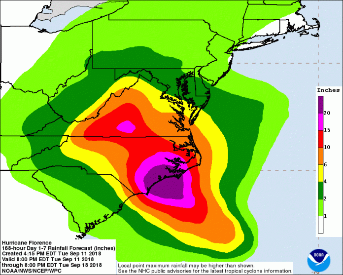
Still, Anderson County’s Director of Emergency Management, David Baker, laid out the possibilities and the responses for the gathering. He referred to two computer models for the storm’s future and its impact based on which scenario developed. The European model, for example, called for as much as five inches of rain for this area, along with possible thirty mile an hour winds. Baker cited the higher than average rainfall already experienced in recent weeks and warned that fallen trees and the attendant damage to power lines could be significant.
The other model shows a much slighter impact with perhaps 1-2 inches of rain, with Anderson county being on the very edge of the weakest quadrant of the storm, which was rated a Category 4 at the time of the briefing. Even as Baker was conducting his briefing, the television news broke in with Governor McMaster’s latest update. He announced that the projected track of the storm had moved northward enough to cancel the mandatory evacuations for the southernmost coastal counties, like Beaufort, Jasper and Colleton counties.
Nevertheless, the possibility of a western or southern shift once the storm makes landfall makes it imperative that preparations continue. Baker said that a possible stall in the storm’s forward movement could significantly increase the amount of rainfall in any given area. “Also, if the storm takes a western jog before it makes landfall, that could also play a significant part in how great an impact we might have here.”
He stated that so far, no requests for manpower or other resources to be deployed nearer the coast had been made by either the state or the federal government.
The above graphic was created by the NWS/NCEP Weather Prediction Center (WPC) and shows rainfall potential for the United States when a tropical cyclone threatens land. The graphic is displayed as a Quantitative Precipitation Forecast (QPF), which shows rainfall totals for a specified time period, based on forecaster discretion. For more rainfall information, visit the Specialized WPC Precipitation Forecasts. For WPC QPFs in KML Format, Click Here.


